Friday, May 27, 2016

Upper Cedar Creek

With the crowds of Memorial Day Weekend beginning to seep into our beautiful Shenandoah Mtns I decided to forgo a trip to the Rapid Anne and try my luck on an unfished section of Cedar Run in the upper reaches of the Robinson River Watershed.  Well, I missed the fisherman on the Rapidan only to find hikers and waterfall jumpers on the Cedar.  Twice before I'd walked up the blue blazed well marked trail and fished to the first major water fall. This is great water and you can see it here. I hit the run at 0830, it was still running at full pool as it has rained here 18 of the last 22 days. The thick, green, fly grabbing foliage was fully budded and at a glance reinforced back cast discipline.  The water was flowing full, fast and cold at 57.  5 cars were in the parking lot when I stepped off, and I hoped I wouldn't encounter any of their hiking occupants for 4-5 hours.   I was wrong.


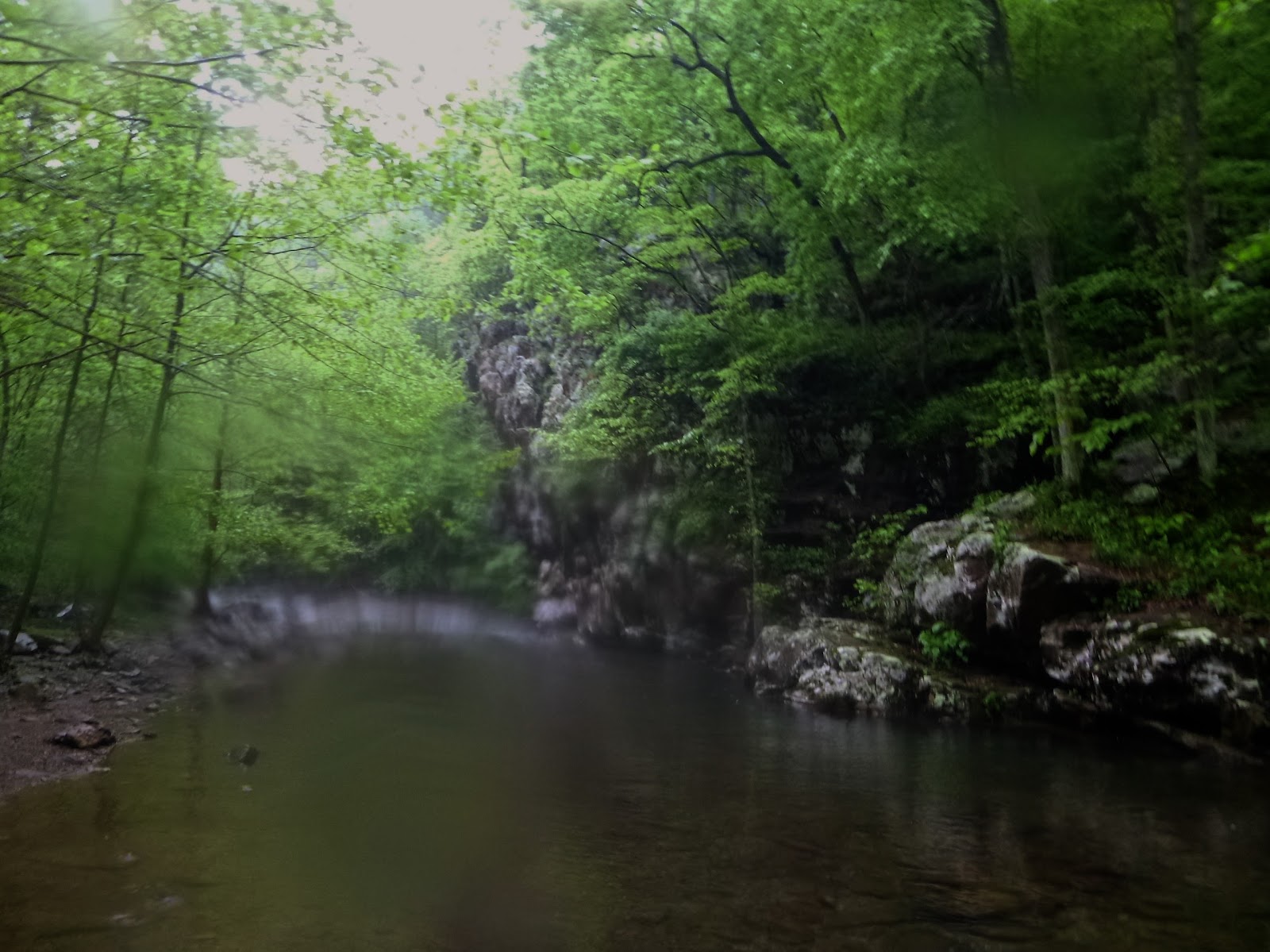
I emerged into the amphitheater of the first waterfall to the glorious crash of water smashing and carving rock, a symphony that's played here for 1000s of years.  The run above the falls was my target but I couldn't resist taking in this beautiful site. just above this first falls a Brookie surface-slapped my #14 parachute Adams and to my unending delight and fascination clamped it into his jaw. The strike, hook set and play is absolutely addicting, a hit of heroine I suppose, and begs another.   I'm hooked too.


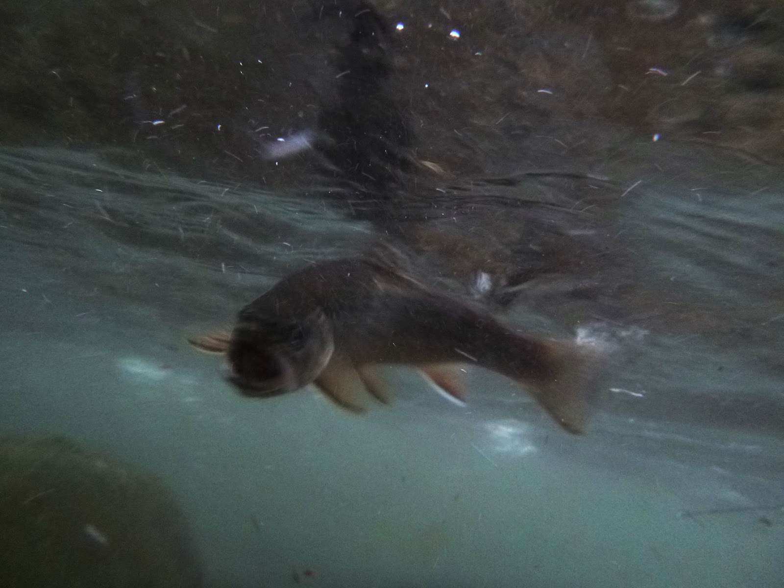
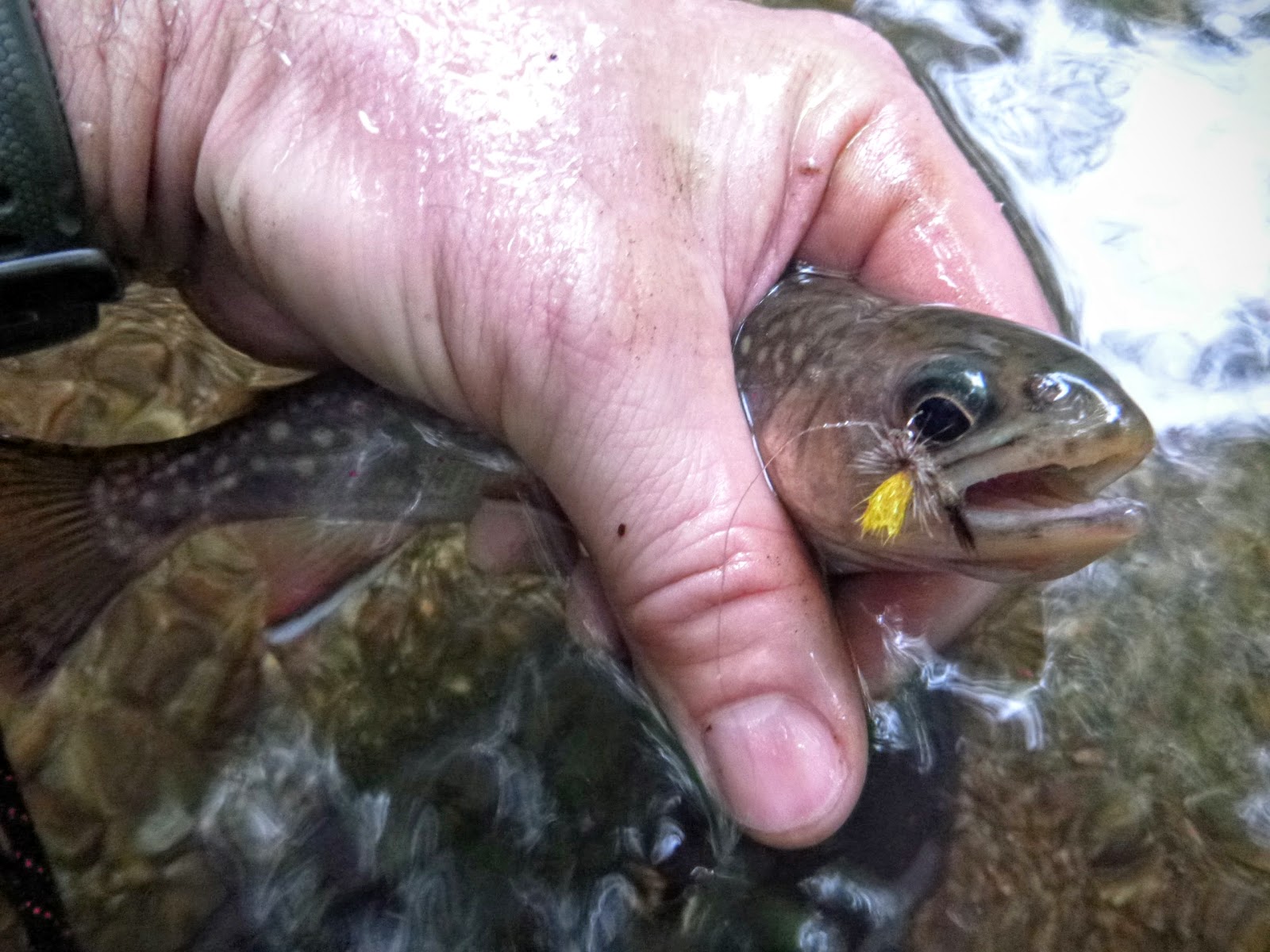
These brook trout have been in Appalachia, here in this mountain run since the dawn of time and when you touch one you feel the cold energy whipping in its little body. My great grandfather Phil Riley would have dispatched them with a thwack of his billy club but today we're more respectful (and don't need to eat them for dinner!).   They're covered with a very light mucus layer so wet your hand before touching them if for some reason you need to lift them out of their watery home. I kept this first one underwater and released him gently to catch another day. 


Then the hikers closed in.   It's hard to begrudge people enjoying these amazing waters but they sure put a bite into the pools as they screamed jumped and generally sent the trout to hiding.  With hikers in the plunge pools I concentrated on the runs between the plunges but the further you ascend the more severe the gradient becomes.  The 8 foot first falls is dwarfed further up by falls approaching approaching 60 feet.  At one point as I hand climbed a mossy wall to the left of a fall I found an old climbing rope still hammered into the face.  This is steep water, really to steep for safe fishing.


I used my 2wt SF and it was perfect for these feisty fellows it's slow action a pleasure to cast light tippets and sensitive blank communicating the vigor of these little fish. The plunge pools and runs are spectacular and beg you to try just one more. 


I ended the day with a spec on my last cast and headed back down the trail, a beautiful day behind me and the promise of the Upper Connecticut River with Henry and Marc next week.


Sunday, May 15, 2016

North Fork Moormans

North Fork Moormans Brookie
If I lived in Charlottesville the North Fork of Moormans River would be my home waters and I'd be very happy. The last time I'd been to this river was with Fritz a decade ago when it was still recovering from the massive deluge and flood that decimated the fishery for years. The water was so high it swept fish away and boulders scoured the banks pushing the protective, cooling foliage-shade from the banks of the river.

Marks the great flood 5 minutes into your walk upstrream

Brook Trout here in Va can't survive the summer sun unless the is filtered by a riparian filter. There are still monuments to the flood here but the river and banks have largely recovered and with an active TU chapter and local catch and release crowd the river is only improving. There's no secret getting to the North Fork, take Barracks road west from Charlottesville through lovely hunt country and stay in it until it turns into Garth Rd. When Garth runs into the hamlet of White Oak stay straight on Sugar Hollow road and park at the end of the road beyond the reservoir which you'll see on your left.


pretty sure you know what this is


When I arrived at the parking area I was surprised to see a dozen other cars tucked into the cul de sac.  Thank fully many of these cars turned out to be hikers.  Moormans River below the reservoir is well stocked and managed by the Charloteesvulle chapter of TU.  I think you have to get a donation-permit to fish it, but I'm not positive. Above the reservoir is well marked stocked water as well.  Here, where the riverbed is wide, you can see make out the damage from the flood.

Two views of Blue Hole Pool @ 1st Crossing -- rain blotting my camera
From the parking take the trail immediately breaking an uphill sweat along the river. The South Fork of Moormans joins quickly, I knew it was there but couldn't see it as the path meanders away from the river up a bluff. I met another angler who suggested that I begin fishing after the second stream crossing and that above the second crossing (effectively the SNP Boundary) was the transition from stocked to native trout water. The view from first stream crossing is the quintessential picture of the North Moormans, a deep sweeping pool at the base of a steep cliff on the right. This pool is known as Blue Hole by UVA students who come here to jump from the cliff into the cold water (so says Conor, a well known jumper in these parts).


As I made my way another 150m to the next crossing and pool the rumbles of thunder and spits of rain announced their presence. A young woman was sketching on a rock at the top of the next pool so I moved upstream of her perch and began casting to likely spots as the patter of rain pushed through the canopy.
Sketcher pool just after the rain


Thankfully I brought three specs to hand before the sky opened up and the fishing shut down.
The deluge had me looking Noah
I didn't get much further up the river before I was soaked and cold. The rain stopped and I was fried. I caught one more trout on will power and then turned back anxious for dry clothes and a nice dinner with Conor.  Next time I come to the North Fork I'll start above the 2nd crossing and move upstream from there. From what I could tell the fishing will only get better as pressure lessens with distance.  A great day today. Trout in the Pocosin, Entry Run, South River and the North Fork.  I ended the day eating with Conor at the Divide a great little Mexican restaurant right by the Amtrak Station near grounds.  Be careful with the danger sauce-- pure habanero!

South River

A south River Brookie waiting patiently (not) to be released 

My previous association with South River came from Scott who tried to find smallmouth on the Middle Rapidan, he mistakenly picked the wrong farm bridge and ended up getting lost on the South, he caught close to a hundred chub before getting deliverance-rescued by some locals in an old pick up truck ~ cue banjos. From that troubled memory untill Thursday I had pondered the Upper Portion of South River as a possible trouting adventure. Indeed the highest trickle of South River can be accessed from Skyline drive from the South River Falls Picnic Area and when the hills are seeping water the upper falls are a hiker destination. Today, South River was just a sip of gas down 642 from my Entry Run Adventure. I parked parallel to the river just off 642, but might have pulled further up and parked off Rock Island Road as well. 

There are houses and huan activity from the 642 up until the RWMA boundary but still fishable

Take the dirt roads right along the river to find parking spot 
As I slid into the cobble I was impressed by the width of the stream bed and how well it bore the high flow. It's aptly named 'river', bigger than a run or a creek and could be easily partner fished. I caught a Brookie on my third cast and satisfied that I'd found access and trout I surveyed the river preparing to scoot, but saw an Adirondack chair on the bank upstream 100m and decided to fish up to it. Wow. Some group had dammed up the river creating three swimming, fishing holes. As scenic as they are (and good for swimming) I suspect that they inhibit trout movement and actually are bad for the overall health of the stream.   There were trout in each but also populations of 3-inch black nose dace (little river shiners) which attacked each dry fly presentation.   3/4 of the strikes in these holes were from the dace.

See in these pics the man-made structure and holes


Further above the lovely artificial holes the river returned to balance and became a lovely trout stream again.   I fish up just a little further than the renovated house on the left. Throughout the course of the day today I never changed out #14 M. Rapidan that enticed so much brook trout attention.


With one more blue line trout stream to fish before dinner with Conor I left the South with plan to come back and headed toward the Mountains West of Charlottesville and the North Fork Moormans.

Friday, May 13, 2016

Entry Run


After leaving the Pocosin I wound my way around Trump and and shine country until I found South River and its major tributary Entry Run off 642 and its smaller cousin 643.


Entry Run Road Parallels Entry Run but is gated where the "P" is and there's available parking for 4-5 cars.  I believe that Collects Run as seen on the map is the run that travels due north but I couldn't see it from the road.


From the Parking proceed up the well marked trail and follow it up the left side of the Run until you choose to hop in.    This is a small run that begins with a relatively low gradient then (a map study reveals) gets much steeper as you push deeper into the darkness.  I walked up for 3 minutes, didn't see any sign of much pressure so I hopped in the stream and even though it too was running high began to slime by #14 Mr. Rapidan with speckled trout goo  :-)


I didn;t stay for long but enough to get the pay of the land bring another half dozen Entry Run
brookies to hand.   It very much looked like a place to explore if the other more popular SNP streams are chocked with fisherman. On my way to entry run I had passed over South River a mile to the south so after a quick sandwich I kicked Jamie's muddy tires and left with another stream to add to my collection.


Pocosin Hollow


Pocosin Trophy in these small waters
I usually leave Jennifer a note when I adventure so she can tell Fritz where to holler for me when I don't come home, but as I kissed Jenny goodbye I couldn't tell her where I planned to be because I didn't know.   I did know and greatly looked forward to ending the day having dinner with Conor in Charlottesville.   With  Northern Virginia still in its perpetual rain cycle, something like 21 of the last 22 days, I was destination-torn between catching a ton of specs on my home waters of the Rapid Anne or exploring new water, new blue-lines, south of the Conway River.  Cedar Creek and the Rappahanock were high and muddy as I passed them and that would usually cause me to opt for clearer, lower water high up in the mountains, but for some reason, I passed the turn to Criglersville and kept jeeping towards Madison, Va.  My plan at that point was park at the lower cul-de-sac access for the Rapidan and fish from there toward the ford (below junction pool) or if the water was too high to fish high up on the Staunton River. At the last minute I bore left at Wolftown Mercantile and headed to toward the Conway watershed.  I had never been on these roads before so armed with my Delorme and a SNP topo I decided to see if there was access to the lower Pocosin just below where 677 is blocked on the west side of the Conway.  Opinions differ about access, but I found it fairly easily and parked roadside as seen on the map.
View looking up Pocosin from 667 just before it enters the Conway

Park where it says shoulder parking
 The Pocosin is a major tributary to the Conway with the same orientation and feel as its twin Devils Ditch another 1.5 miles up the Conway.   From the parking area along 667 a sign indicates that its .6 miles (all uphill ;-) to the SNP gate.    Take the streamside trail for 3 minutes, you'll come to Hidden Valley Road, bear right on the road and about 14 minutes after leaving parking you'll see a gate, pass the gate and continue up the well-posted trail until you reach the SNP marker at about 17 minutes.    Fish up from there. 


Follow this trail


keep walking

Start fishing here (or move up if you like)


As I slid into the Pocosin I thought it was skinny and then found that this section of the Pocosin is disaggregated into several runs and I caught my first spec on an UNT coming in from my left.


Branch was not broken until it broke on me sending me to a spill
Caught first spec in this UNT of the Pocosin

UNT of Pocosin
  As I fought uphill and to the main stem I found that the Poscosin actually fished bigger as you climb it.   The terrain channelizes it into a central flow about 150m upstream from where I entered it.
Pocosin separates and joins at this point 100 up from SNP boundary -- fish upstream of this little island for bigger water
Aggregated Pocosin above island -- nice water

Light filtered into this hole beautifully


  Here it's still narrow and tight, but there's plenty of water and pools to hold brookies all year.   Really nice water and a fisherman would do well to spend a day sneaking up its rock chocked path.   The brookies here don't see much attention and my Mr. Rapidan was like a steak to a starving dog.

flapping tail captured (not) by the camera setting


  I caught brookies for an hour and then headed back to Jamie to unlock the mysteries of the next stream on my hit list, Entry Run.